Reading Lake Structure for Maine Bass
Have you ever found yourself on a beautiful Maine lake, staring out at seemingly endless water, wondering where on earth the bass decided to hide today? It’s a common frustration for many anglers, myself included. Those wily smallmouth and largemouth bass aren’t just swimming aimlessly; they are creatures of habit, and those habits are almost always tied to the underwater landscape. This guide is all about helping you decode that hidden world, teaching you how to read lake structure for Maine bass and drastically improve your chances of a successful day on the water.
Understanding the Basics of Lake Structure for Bass
Before we dive into specific types of structure, it's really important to understand the fundamental concept of why bass relate to these features and the subtle differences between what we call "structure" and "cover." Getting these basics down will lay a solid foundation for finding those fish, whether you're on a vast body of water like Sebago Lake or a smaller, intimate pond.
Why Bass Relate to Structure
Think about it from a bass's perspective. They're predatory fish, but they're also prey themselves, especially when they're smaller. This means they need places to ambush unsuspecting meals and places to hide from larger predators like ospreys, eagles, or even bigger fish. Structure provides these vital services. It offers protection from strong currents, gives them vantage points to spot food, and creates temperature breaks where they can find comfortable water.
In essence, structure is like real estate for a bass. Good structure means easy access to food, safety, and comfort. If you can identify these prime pieces of "real estate," you're halfway to finding the fish. It's not just about finding any old bump on the bottom; it’s about understanding why that specific bump, drop-off, or weed line is appealing to a bass at a given time. Their entire lives revolve around these underwater features, from spawning to feeding to seeking refuge during harsh weather or intense sunlight.
Structure vs. Cover: What's the Difference?
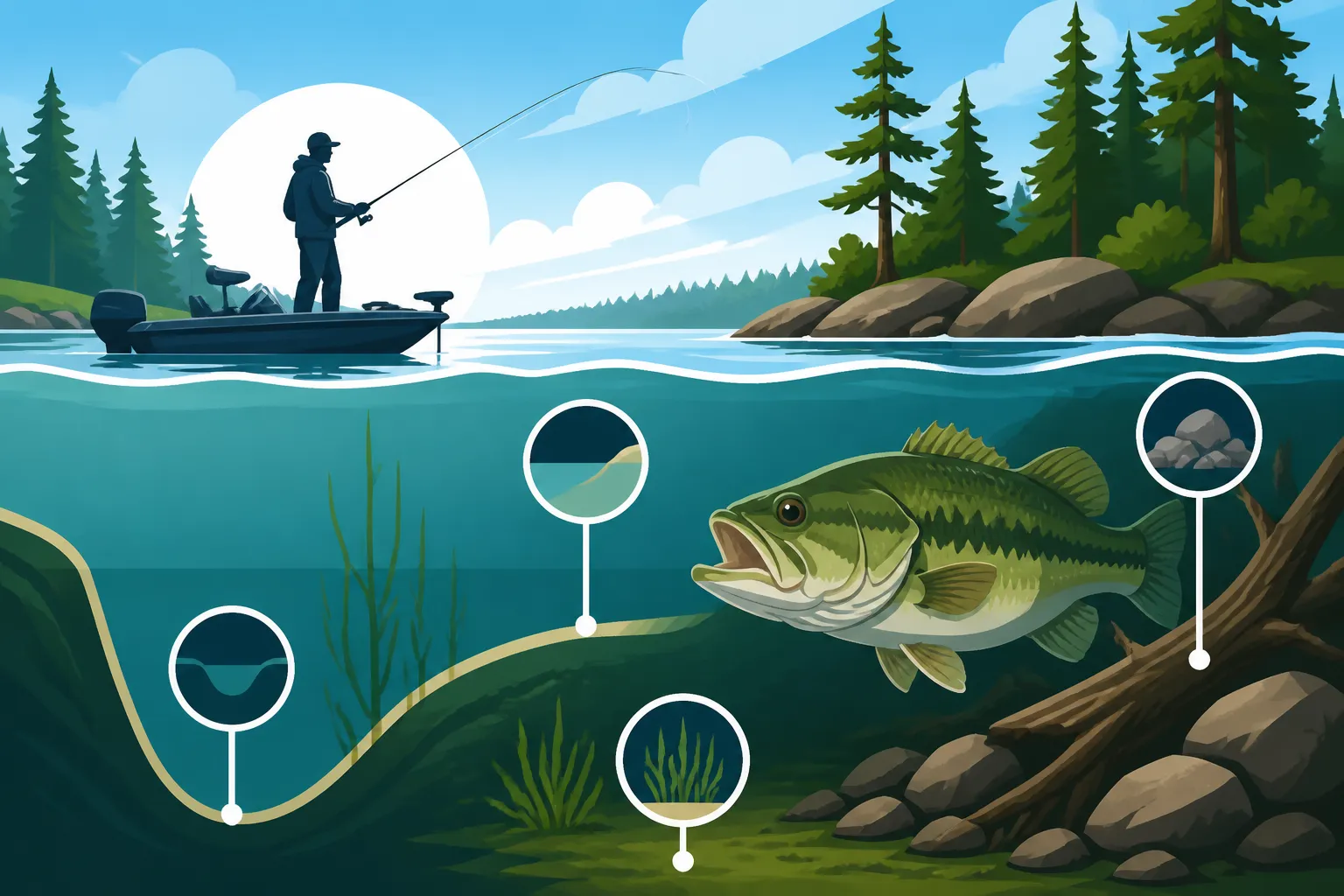
This is a distinction that often trips up new anglers, but it's crucial for effective bass fishing. Simply put, structure refers to the actual physical features of the lakebed—things that are part of the lake's topography. These are permanent changes to the bottom contour. Think of submerged points, rock piles, ledges, old creek channels, humps, or even entire roadbeds from flooded areas. They are part of the lake's bones.
Cover, on the other hand, is anything on the structure or in the water column that offers concealment or protection. This could be a fallen tree, a dock, lily pads, submerged weed beds, a patch of brush, or even a boat. Cover is often more transient; a weed bed might die back in winter, or a log could shift in a storm. While bass certainly use cover heavily, especially largemouth, that cover is almost always associated with some kind of underlying structure. For instance, a dense patch of lily pads might be growing on a shallow flat, which is the structure. The pads themselves are the cover. Understanding this means you're not just looking for a floating log, but asking why that log is there and what lies beneath it on the bottom.
Key Types of Lake Structure for Bass
Now that we've got the basics down, let's explore the specific types of underwater structure that consistently attract bass in Maine lakes. From the sprawling depths of Moosehead Lake to the productive waters of the Belgrade Lakes, these features are universal magnets for both smallmouth and largemouth. Learning to recognize and target them will significantly boost your catch rates.
Points and Submerged Ridges
Points are arguably one of the most classic and reliable bass-holding structures out there, and for good reason. A point is essentially a finger of land that extends out into the lake, either visible above water or fully submerged. These features act like underwater highways, providing bass with easy access to both shallow feeding grounds and deeper, safer waters. They're natural ambush spots where bass can wait for baitfish to swim by.
Submerged ridges are similar but often run parallel to the shore or connect two distinct pieces of structure. Both points and ridges typically have varying depths, offering a range of conditions. On a single point, you might find a shallow flat, a sharp drop-off, and scattered rocks, all within a small area. The "sweet spot" on a point often lies where the contour changes most dramatically—a sudden break, a cluster of rocks, or the edge of a weed line. Anglers often find success by casting across the point and working their lure down each side. In Maine, you'll find these points on almost every lake, and they're always worth investigating, especially during transitional periods like spring and fall.
Drop-Offs and Ledges
Drop-offs and ledges are literally what their names suggest: sudden changes in depth where the lakebed steeply declines. These are incredibly important for bass, particularly smallmouth, who love to suspend or cruise along these vertical breaks. Ledges can be subtle, only dropping a few feet, or they can be dramatic, plunging into deep water. They offer bass instant access to different temperature zones, oxygen levels, and cover.
Bass will often stage on the shallower side of a drop-off, darting out to ambush baitfish that swim over the edge, or they might hold tight to the vertical face of the ledge, completely hidden from above. Understanding how to Reading Lake Structure for Bass involves not just finding these, but understanding how subtle changes in the contour of a ledge can concentrate fish. A small indentation, a chunk of rock, or a lone tree stump on a ledge could hold a trophy bass. Your fish finder, especially a good side-imaging unit you might find on Amazon, will be your best friend in locating these critical deep-water transitions. These are prime areas to explore, particularly during the hot summer months when bass retreat from scorching shallow water.
Humps and Roadbeds
Humps are isolated, elevated areas on the lake bottom that are completely surrounded by deeper water. Imagine an underwater island, and you've got a hump. These can be tiny rises or vast plateaus, but their appeal to bass is universal: they offer an elevated feeding station in deeper water, making them excellent ambush points. Bass can hold on the top, along the sides, or at the base of a hump, depending on conditions and baitfish activity.
Old roadbeds, on the other hand, are relics of a bygone era, often found in reservoirs or lakes formed by damming. When a valley is flooded, the old roads, bridges, and foundations remain, creating linear, hard-bottomed structures that bass absolutely adore. These often provide a consistent depth, unique composition (gravel, asphalt, concrete), and distinct edges that contrast sharply with the softer surrounding bottom. Bass will patrol these old pathways like highways, using them for travel and feeding. Finding an old roadbed on a topo map can unlock a consistent bass pattern, especially if it connects to other major structures like a river channel or a deep flat. Many experienced anglers keep a keen eye out for these historical clues when studying their charts.
Deep Water Channels and Creek Beds
While points, humps, and ledges offer vertical relief, deep water channels and old creek beds provide linear structure, cutting paths through the lake bottom. These are essentially the remnants of ancient rivers or streams that flowed through the landscape before the lake was formed. They are often deeper than the surrounding bottom and can act as thermal refuges or travel corridors for bass.
In large Maine lakes, these channels can be extensive, sometimes winding for miles. Bass, especially big smallmouth, will use the deeper parts of these channels as highways to move between different feeding areas, or they might hold along the channel edges, where the bottom abruptly drops off. If a channel makes a bend, has a junction with another channel, or features some unique cover (like a submerged tree), it becomes even more productive. Baitfish often congregate in these channels, naturally drawing in predators. For example, on the expansive Sebago Lake, identifying these old channels can be key to unlocking productive offshore Smallmouth Bass Fishing in Maine. These are especially critical in summer, when bass often follow these deep contours to find cooler, oxygen-rich water.
Tools and Techniques for Identifying Structure
Knowing what structure bass like is only half the battle. The real challenge, and the real fun, is figuring out where it is in the vastness of a Maine lake. Luckily, modern technology and some old-school methods can help you paint a detailed picture of the underwater world.
Sonar and Fish Finders
Without a doubt, a good fish finder is the most indispensable tool for reading lake structure today. Modern sonar units have advanced dramatically, offering technologies that were once only available to commercial fishermen.
- 2D Sonar: This is your traditional down-looking sonar, showing you the bottom contour directly beneath your boat and marking fish arches. It's excellent for identifying drop-offs, humps, and individual fish.
- Down Imaging/DownScan: This technology provides a picture-like view of what's directly beneath your boat, making it much easier to differentiate between rock piles, brush, and even individual fish. It's fantastic for seeing the texture of the bottom.
- Side Imaging/SideScan: This is a game-changer for covering water. It sends sonar beams out to the sides of your boat, creating a wide swath of the bottom. With side imaging, you can literally "see" points, humps, ledges, and even isolated cover like stumps or rock piles off to the side, allowing you to identify structure without driving directly over it. This saves an incredible amount of time and helps you pinpoint exact casting targets.
When using your sonar, pay close attention to changes in the bottom reading. A sudden change in depth, a harder return (indicating rock or gravel), or marks indicating baitfish or larger arcs are all clues. Units from brands like Humminbird or Lowrance are incredibly popular among bass anglers, and you can find a wide range of options on Amazon to suit any budget or boat. Learning Reading a Fish Finder on Maine Lakes takes time and practice, but it's an investment that pays off immensely.
Topographic Maps and Navigational Charts
Before you even launch your boat, topographic maps and navigational charts should be your first point of reference. These provide a bird's-eye view of the lake's contours, showing you depth changes, old creek beds, humps, and points before you get there. Many GPS units now come pre-loaded with highly detailed maps, or you can purchase digital maps from companies like Navionics or C-MAP.
Look for areas where contour lines are close together—this indicates a steep drop-off. Where they are spread far apart, you have a gentle slope or a flat. Follow old creek beds (often marked with dashed lines) and look for where they intersect with points or humps. Identify areas where the map shows isolated depths or rises. These maps allow you to develop a "milk run" of potential spots before you even hit the water, giving you a strategic advantage. For example, if you're exploring Cobbosseecontee Lake for bass, studying a detailed chart beforehand can reveal key underwater features that might not be obvious from the surface.
On-Water Observation and Probing
While technology is powerful, don't underestimate the value of your own eyes and senses.
- Visual Cues: Look for changes in water color, which can indicate different depths or bottom compositions. Observe how the wind affects the water surface; areas with current or eddies might hint at underwater obstructions. Pay attention to bird activity, especially loons or ospreys, as they often target baitfish that are themselves holding around structure. In clear Maine waters, you might even spot rock piles or weed edges in shallower areas.
- Probing and Feeling the Bottom: This is a technique as old as fishing itself. When casting, pay attention to how your lure feels as it retrieves along the bottom. Does it bump over rocks? Drag through mud? Snag on weeds? These sensations tell you a lot about the bottom composition. Using a heavy jig or a Carolina rig can be particularly effective for "feeling" the contours and transitions. When you hook up a fish, make a mental note (or better yet, a waypoint on your GPS) of the exact spot where it happened. Was it on the edge of the weeds? On a small rock? This direct feedback is invaluable for refining your understanding of structure.
Seasonal Structure Patterns for Maine Bass
Bass don't use structure in the same way all year round. Their behavior is heavily influenced by water temperature, available forage, and spawning cycles. Understanding these seasonal shifts is crucial for consistently finding fish in Maine's varied conditions, from the icy grip of winter to the dog days of summer.
Spring: Pre-spawn and Spawning Structure
Ah, spring! The ice is finally out, and bass start to shake off their winter lethargy. This is a truly exciting time for Maine Spring Fishing Guide.
- Pre-spawn: As water temperatures creep into the upper 40s and 50s Fahrenheit, bass begin to move from their deeper wintering holes towards shallower staging areas. They're looking for structure that offers a good transition—like points that extend into deep water, rocky ledges, or the mouths of coves. These spots allow them to warm up quickly in the sun, feed heavily, and still retreat to deeper, more stable water if a cold front rolls through. Look for areas with a dark bottom (rock or mud) that absorbs heat faster. Shallow humps or submerged points near deep water are bass magnets during this period. Baitfish are often the key, so finding structure holding schools of smelt or other forage will be paramount.
- Spawning: Once the water temperature consistently reaches the mid-50s to low 60s, bass begin to spawn. They'll move into very shallow, protected areas—often bays, coves, or pockets with hard bottoms (sand, gravel, small rock) and some form of cover like docks, logs, or sparse weeds. The structure here is less about depth changes and more about protection. They prefer northern-facing banks that get maximum sun exposure. Look for visible nests (circular cleared areas) or cruising fish guarding their territories. While it's tempting to target bedding bass, many anglers practice catch-and-release to protect the spawn.
Summer: Deep Water and Thermocline Structure
Maine summers can get hot, and so can the surface water of our lakes. As temperatures rise into the 70s and 80s, bass often retreat to deeper, cooler, and more oxygenated waters. This is when understanding offshore structure becomes absolutely critical.
- The Thermocline: Many Maine lakes develop a thermocline in summer—a distinct layer where the water temperature rapidly changes. Bass, especially smallmouth, will often suspend or hold just above or within this thermocline, as it offers ideal temperature and oxygen levels. Your fish finder will often show this as a dense, blurry line. Targeting structure like deep humps, offshore ledges, deep points, or the edges of old river channels that extend into the thermocline zone is key. Bass will use these features as cover and ambush points within their preferred temperature range.
- Early and Late Summer: In early summer, bass might still be found shallower during low-light conditions (dawn, dusk, cloudy days), especially around weed lines or shaded docks. But as the sun climbs high, they'll pull out to those deeper structural elements. Late summer can see bass becoming more aggressive again as water temperatures begin to slowly drop, signaling the approaching fall feeding frenzy. Always be mindful of the available forage, as schools of baitfish will also be using deep structure, drawing bass in. Learning How to Fish Deep Water for Summer Trout can give you insights into similar tactics for bass.
Fall: Feeding Frenzy Structure
Fall is a phenomenal time for bass fishing in Maine. As water temperatures cool down, bass go on a major feeding binge, trying to pack on weight for the lean winter months. They become incredibly aggressive and will actively chase bait.
- Transitional Areas: Bass will move back towards shallower water, particularly areas that offer a mix of deep-water access and abundant forage. This means points, shallow humps, rock piles, and deep weed edges become prime locations. They’ll often follow baitfish into coves and bays during the day and retreat to the deeper ends of these structures at night.
- Cover and Bait: Look for structure that still has active cover, like green weed beds, fallen trees, or brush piles, as baitfish will be hiding there. As the water cools further, shallow flats might become less productive, and bass will concentrate on the steeper drops and deeper breaks of offshore structure. The key is finding bait. If you locate schools of baitfish on your sonar, you can bet that bass won't be far behind. This is a great time to deploy techniques like power fishing or even targeting them with Best Lures for Smallmouth Bass in Maine or Best Bait for Largemouth Bass in Maine.
Putting It All Together: Strategies for Success
Reading lake structure for bass isn't just about identifying a point or a hump; it's about developing a strategic approach to fishing these areas effectively. It involves combining your knowledge of structure, your tools, and an understanding of seasonal patterns to present your lure in the right place at the right time.
Developing a Search Pattern
When you arrive at a new lake or a new area of a familiar lake, don't just randomly cast. Have a plan.
- Map Study: Start by reviewing your topographic map or digital chart. Identify potential key structures like major points, significant drop-offs, humps, or old creek channels. Pick out 3-5 promising spots to start with.
- Sonar Scouting: Once on the water, use your boat's sonar, especially side imaging, to thoroughly scan these identified areas. Don't just drive over them quickly. Take your time, making wide passes to understand the full scope of the structure. Look for subtle changes, isolated cover, or schools of baitfish. Mark any promising spots with waypoints on your GPS.
- Targeted Fishing: Once you've identified a specific piece of structure that looks promising, approach it carefully. Make your first casts to the most likely holding areas—the deepest edge of a weed line, the tip of a point, the steepest part of a drop-off, or around any isolated cover you spotted. Work your way around the structure, experimenting with different angles and depths.
For example, if you're fishing the Belgrade Lakes Bass Fishing in Maine and identify a long, submerged point extending from shore, you might start by casting parallel to one side, then cross the tip, and then work down the other side, paying close attention to any changes in bottom feel or depth.
Adjusting to Conditions
Bass are fickle creatures, and what worked yesterday might not work today. Conditions like weather, wind, and time of day significantly influence where bass position themselves on structure.
- Weather: Cloudy, overcast days often encourage bass to move shallower and be more aggressive. Bright, sunny days might push them deeper or tighter to heavy cover for shade. After a major storm, bass might be disoriented or pushed into different areas; conversely, a warm rain can sometimes trigger a bite. Keep an eye on the Best Weather Conditions for Bass Fishing.
- Wind: Wind can be your friend! A consistent breeze pushing across a point or a flat can create a "current" that positions baitfish. Bass will often face into this current, waiting for an easy meal. Focus on the windblown side of structures, as this is often where baitfish are concentrated and oxygen levels are higher. However, strong winds can also make boat control difficult, especially when trying to hold over a precise piece of deep structure. Learn How Wind Affects Lake Fishing to use it to your advantage.
- Time of Day: Early morning and late evening are often prime times for bass to be actively feeding in shallower water, especially around the edges of structure. During midday, particularly in summer, they're more likely to be found deeper or tucked into heavy overhead cover. Adjust your target structure and fishing depth accordingly.
Practice and Patience
Learning to truly "read" lake structure isn't something that happens overnight. It takes practice, patience, and a willingness to experiment. Every lake is unique, and even within the same lake, different areas will have different characteristics.
- Keep a Log: Consider keeping a fishing log. Note the date, time, weather conditions, water temperature, the specific structure you were fishing, the lure you used, and whether you caught fish. Over time, you'll start to see patterns emerge that will help you predict where bass will be under similar conditions.
- Don't Be Afraid to Experiment: If a spot isn't producing, don't bang your head against the wall. Move on. Try different lures, different depths, and different retrieval speeds. Sometimes a subtle change in presentation is all it takes to trigger a bite.
- Learn from Others: Watch videos, read articles (like this one!), and talk to experienced local anglers. Maine has a passionate bass fishing community, and many are willing to share general knowledge, though probably not their secret spots! Consider hiring a local Maine Lake Fishing Guides for a day; they can drastically shorten your learning curve on specific waters.
By dedicating yourself to understanding and applying these principles, you'll find yourself not just randomly casting, but strategically targeting bass where they live. That feeling of confidently pulling a bass off a piece of structure you found on your map or sonar is incredibly rewarding, and it's what makes bass fishing in Maine so addictive.
Maine Bass Structure Table
This table provides a quick overview of common lake structures and their typical appeal to bass, helping you quickly identify where to focus your efforts.
| Structure Type | Description | Bass Appeal | Key Seasons | Common Baits/Lures |
|---|---|---|---|---|
| Points | Fingers of land or rock extending into the lake, often with varying depths. | Ambush points for passing baitfish; access to shallow/deep water; transition zones. | Spring, Summer, Fall | Crankbaits, Jigs, Spinnerbaits, Texas Rigs, Drop Shots |
| Drop-Offs / Ledges | Steep changes in depth, creating a vertical "wall" or sharp incline on the lakebed. | Thermal refuge in summer; ambush positions; travel routes; smallmouth often suspend along them. | Spring, Summer, Fall | Jigs, Drop Shots, Deep Diving Crankbaits, Carolina Rigs, Tubes |
| Humps | Isolated, elevated areas on the lake bottom surrounded by deeper water. | Offshore feeding stations; current breaks; concentrate baitfish; offer multiple depths for bass to hold. | Summer, Fall | Jigs, Carolina Rigs, Deep Diving Crankbaits, Football Jigs, Spoons |
| Roadbeds / Foundations | Submerged remnants of old roads, bridges, or building foundations from flooded areas. | Hard-bottomed travel corridors; distinct edges; unique cover features; contrast with soft bottom. | Spring, Summer, Fall | Crankbaits, Carolina Rigs, Jigs, Wacky Worms, Spinnerbaits |
| Deep Water Channels | Submerged river or creek beds cutting through the lake bottom, usually deeper than surrounding areas. | Travel routes; thermal refuge in summer; concentrate baitfish; edges provide ambush points. | Summer, Fall | Deep Diving Crankbaits, Jigs, Carolina Rigs, Drop Shots, Spoons |
| Weed Lines / Beds | Edges or dense patches of submerged vegetation. | Excellent cover and oxygen; hold baitfish; ambush points for bass (especially largemouth). Often associated with underlying structure. | Spring, Summer, Fall | Jigs, Spinnerbaits, Topwater, Frogs, Texas Rigs, Flipping Baits |
| Rock Piles / Boulders | Accumulations of rocks, ranging from small rubble to large boulders. | Provide cover, warmth, and ambush points; attract crayfish and baitfish. | Spring, Summer, Fall (especially rocky points/ledges) | Jigs, Tubes, Crankbaits (shallow/medium), Spinnerbaits, Football Jigs |
| Wood (Laydowns, Stumps) | Fallen trees, submerged logs, or stumps. | Excellent cover and shade; ambush points; create current breaks. Often associated with shorelines or channel edges. | Spring, Summer, Fall (especially near shallow water or channel edges) | Jigs, Texas Rigs, Spinnerbaits, Buzzbaits, Shallow Diving Crankbaits |
Disclaimer
Fishing regulations and conditions in Maine can change. Always consult the latest Maine Department of Inland Fisheries and Wildlife (MDIFW) regulations before heading out on the water. This guide is for informational purposes only and should not replace official sources. Practice safe boating and fishing, and always prioritize conservation and ethical angling practices.