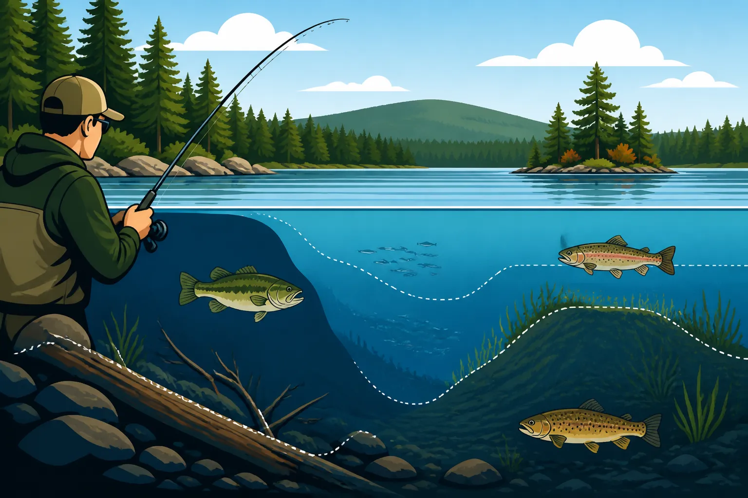
Reading Lake Structure for Bass and Trout
Many anglers, especially those new to Maine's vast and beautiful waters, find themselves casting blindly, hoping for a bite without a clear strategy. It's easy to feel overwhelmed by the sheer size of our lakes and rivers, wondering where on earth the fish might be hiding. This guide is designed to cut through that frustration, teaching you how to "read" the underwater landscape and identify the key structures where bass, trout, and salmon congregate, dramatically improving your fishing success.
Why Lake Structure is the Angler's Secret Weapon
Think of a lake not as a flat, featureless body of water, but as a submerged landscape with hills, valleys, roads, and neighborhoods. Just like us, fish don't just hang out randomly; they prefer certain "neighborhoods" that offer comfort, safety, and a good meal. Understanding these underwater features, or "structure," is the fundamental difference between a hit-or-miss day and a consistent, productive outing.
Decoding Fish Motives: Why They Hang Around Structure
Fish are driven by basic needs: food, safety, and comfort. Structure provides all three. For predators like bass and salmon, structure offers ideal ambush points where they can hide and dart out to snatch unsuspecting baitfish. It also serves as cover from larger predators (though in many Maine lakes, the angler is the top predator!). Structure can also provide thermal relief; a deep drop-off might offer cooler, oxygen-rich water on a scorching summer day, while a sun-drenched rock pile can warm up quickly in early spring, attracting baitfish and hungry gamefish alike.
Consider a big, open lake like Sebago. If you just motor out to the middle and start casting, your chances of success are slim. But if you know there's a submerged hump rising from 60 feet to 20 feet, topped with rocks and some scattered weeds, suddenly you have a target. That hump is a fish magnet, a hub of activity. It's a place where baitfish feed, and bigger fish lie in wait. Structure isn't just an obstacle; it's a dynamic ecosystem within the larger lake, crucial for understanding fish behavior and maximizing your time on the water.
The Maine Lake Labyrinth: Common Structural Features
Maine's diverse geology means our lakes offer a rich tapestry of underwater structures. You'll find everything from glacially carved ledges to boulder fields and sandy flats. Knowing what these features are called and what they typically mean for fish location is vital.
- Points: These are extensions of land that project into the water, often continuing underwater as submerged ridges or shoals. Points are prime locations because they offer transition zones – areas where shallow water meets deeper water, and where different types of bottom (rock, sand, weed) often converge. Fish will use points to ambush bait moving along the shore or to transition between different depths.
- Humps and Islands: Humps are submerged hills that rise from the lake bottom but don't break the surface. Islands, of course, are visible, but their underwater structure often extends far beyond their shores, creating complex rocky reefs and ledges. Both provide elevated feeding areas and cover in deeper water.
- Ledges and Drop-Offs: A ledge is a distinct break in the bottom contour, often a sharp vertical or near-vertical wall. Drop-offs are slopes where the depth dramatically increases. These are crucial for fish that move vertically through the water column, offering quick access to different temperatures and depths. Many trout and salmon species will patrol these depths, especially during warmer months.
- Weed Lines and Submerged Vegetation: While some lakes are clearer, many Maine waters have abundant aquatic vegetation. The edges of these weed beds, or "weed lines," are incredibly productive. Weeds provide cover, oxygen, and habitat for baitfish and invertebrates, making them prime hunting grounds for bass, pickerel, and even some trout species, particularly in low-light conditions.
- Rock Piles and Boulder Fields: These offer excellent cover and ambush points, especially for smallmouth bass and even some brook trout in specific environments. The crevices provide shelter, and the rocks themselves can hold heat or attract algae, which in turn attracts smaller organisms.
- Submerged Timber and Laydowns: Fallen trees, old stumps, and brush piles are fantastic cover, especially for largemouth bass. These provide shade, protection, and a place to hide from prey. However, they can be tricky to fish without getting snagged!
Your Toolkit for Uncovering Underwater Hotspots
You don't need to be a marine biologist to find fish-holding structure. Modern tools make it easier than ever to explore the underwater world. A little bit of homework before you even launch your boat, combined with smart use of technology on the water, will put you leaps and bounds ahead of the casual angler.
Maps and Charts: Your Underwater Blueprints
Before you even leave your driveway, you can gain a massive advantage by studying navigational charts and bathymetric maps. These are essentially topographical maps of the lake bottom. Look for contour lines, which connect points of equal depth. Closely spaced contour lines indicate a steep drop-off or ledge, while widely spaced lines suggest a gradual slope.
- Reading Contours: Imagine you're walking across the bottom of the lake (if only!). Contour lines show you where you'd be going uphill or downhill. Look for areas where contours "pinch" together (steep break), or where they form distinct humps, saddles, or points. These are often where fish will be concentrated. You can find excellent charts for most major Maine lakes online or sometimes even at local sporting goods stores. Spend time marking potential spots on a physical map or digitally on your phone. This pre-trip reconnaissance is invaluable for developing a game plan and understanding the overall structure of a body of water, whether you're targeting brook trout or smallmouth bass.
- Importance of Pre-Trip Planning: By studying maps, you can identify a handful of promising spots before you even get to the launch. This means less aimless driving around and more time fishing in high-percentage areas. You can also get a feel for the terrain, noting potential hazards or key access points. Planning helps you understand the bigger picture of the lake, like how shallow flats connect to deep channels, or where underwater springs might create cold water pockets – crucial for species like the Landlocked Salmon. Remember that your Maine Fishing Regulations Explained knowledge might also come into play during this planning phase, as certain areas might have specific rules.
The Eyes Below the Surface: Mastering Your Fish Finder
Once you're on the water, your fish finder becomes your most powerful tool for confirming what your maps suggested and discovering new structure. Today's sonar technology offers incredible detail, but it takes practice to interpret what you're seeing.
- Types of Sonar Technology:
- 2D Sonar: This is your traditional fish finder view, showing you what's directly beneath your boat. You'll see fish arches, the bottom contour, and any structure directly in the sonar cone.
- Down Imaging (or DownVu/DownScan): This technology provides a picture-like view of what's directly below, much clearer than 2D sonar for identifying submerged timber, rock piles, or weed lines. You can truly see the shape of the structure.
- Side Imaging (or SideVu/SideScan): This is a game-changer for covering water. It sends sonar beams out to the sides of your boat, creating a wide view of the bottom. You can scan large areas for humps, ledges, or submerged objects without having to drive directly over them. This is especially useful on vast lakes when you're trying to quickly locate promising areas for Smallmouth Bass Fishing in Maine.
- Interpreting What You See: Learning to read your fish finder is like learning a new language. You'll want to distinguish between hard bottom (rock, gravel) which appears thicker and often brighter on the screen, and soft bottom (mud, silt) which is thinner and less defined. Fish arches indicate individual fish, while schools of baitfish might look like clouds. Understanding how your screen displays weed lines versus rock piles takes time, but it's essential. Many anglers find their fish finder invaluable for trolling, too, helping them maintain the right depth and track contours, which is often key for species like lake trout. You can find a lot of great fish finder models and accessories on Amazon, often with detailed descriptions and user reviews that can help you understand their features. A dedicated guide on Reading a Fish Finder on Maine Lakes could delve even deeper into this topic.
Targeting Bass on Their Structural Turf
Bass, both smallmouth and largemouth, are incredibly structure-oriented fish, but they have distinct preferences. Knowing these differences will help you refine your approach and choose the right spots.
Smallmouth and Largemouth: Different Structure, Different Strategies
While both are "bass," their preferred habitats often differ, especially in Maine's varied lakes.
- Smallmouth Bass: These bronze bombers are typically found in clearer, rockier lakes and prefer hard bottom structure. Think gravel, boulders, and rocky ledges. They are often found deeper than largemouth, especially during midday or in the summer heat.
- Key Smallmouth Structures: Look for rocky points that extend into the main lake, submerged humps with gravel tops, and deepwater ledges or drop-offs. In lakes like Sebago Lake, smallmouth will often relate to current breaks around islands or shoals. They love transition zones where they can patrol deeper water and quickly move shallow to ambush bait. Don't be afraid to target deep water for smallmouth, especially when the sun is high.
- Fishing Strategy: Vertical jigging, drop-shotting, or casting crankbaits and tubes along these rocky structures are often effective. Pay close attention to your fish finder for schools of baitfish congregated around these features, as smallmouth won't be far behind.
- Largemouth Bass: Our green-backed friends prefer warmer, shallower, and often weedier waters. They are ambush predators who thrive in areas with abundant cover.
- Key Largemouth Structures: Focus on dense weed beds, lily pad fields, submerged timber (like fallen trees or old stumps), and docks or other man-made structures. The inner and outer edges of weed lines are critical. Look for areas with a mix of cover and open water, providing them both shelter and a clear path to strike. Many of Maine's smaller ponds and the shallower coves of larger lakes are prime largemouth territory.
- Fishing Strategy: Flipping jigs into heavy cover, Texas-rigging soft plastics through weeds, or throwing topwater lures over lily pads are classic largemouth tactics. Remember that Largemouth Bass Fishing in Maine often means targeting dense cover, so heavy line and stout rods are often necessary to pull them out.
The Seasonal Structure Shuffle for Bass
Bass don't stay in the same spots all year. Their relationship with structure changes dramatically with water temperature and spawning cycles.
- Spring (Pre-Spawn & Spawn): As ice recedes and water temperatures climb, bass move from their deep wintering holes to shallower "staging" areas. Look for protected coves, sun-warmed flats, and rocky points near spawning grounds. They'll often be found near submerged wood or darker bottom that absorbs sunlight. During the spawn, largemouth will be in very shallow, protected areas, often near docks or brush, while smallmouth might favor rocky pockets. Check your Maine Spring Fishing Guide for more specific timing.
- Summer (Post-Spawn & Summer Heat): After spawning, bass will often feed aggressively before settling into their summer patterns. When the water gets hot, smallmouth move to deeper, cooler, oxygen-rich humps, ledges, and rocky points. Largemouth might burrow deeper into dense weed beds, seek shade under docks or overhanging trees, or move to main lake points with access to deeper water. Early morning and late evening topwater bites can be fantastic during this time, but during the day, they'll be holding tight to cover or structure. Is Summer a Good Time to Fish in Maine? for bass? Absolutely, if you know where to look.
- Fall (Feeding Frenzy): As water temperatures drop, bass embark on a major feeding binge to bulk up for winter. They'll often be found on large flats, main lake points, and transition areas where baitfish are congregating. They're often less cover-shy and more actively cruising. Look for schools of baitfish on your fish finder and bass will be nearby. Understanding Maine Bass Fishing Limits by Zone is crucial, especially during this active feeding period.
Unlocking Trout and Salmon Sanctuaries
While bass might be drawn to warmer, weedier spots, Maine's prized coldwater species – landlocked salmon, brook trout, and togue – have a distinct preference for cold, clean water and specific structural elements.
Coldwater Kings: Preferred Structures for Salmon, Brookies, and Togue
These fish are highly sensitive to water temperature and oxygen levels, making specific types of structure critical to their survival and your success.
- Landlocked Salmon: These powerful fighters prefer open water but will relate strongly to structure that provides access to deep, cool water and areas where baitfish congregate.
- Key Salmon Structures: Look for main lake points, submerged humps, and the edges of steep drop-offs, especially where these features are exposed to current or wind. Salmon often suspend over deep water near these structures, ambushing smelt and other baitfish. During the spawn, they will move into rivers and tributary mouths. You'll often find them roaming near the thermocline in summer. Our Landlocked Salmon Fishing in Maine guide has even more detail on these majestic fish.
- Fishing Strategy: Trolling with spoons, stickbaits, or baitfish imitations at specific depths is a common and highly effective method. Using downriggers or lead core line helps present your lure at the right depth, often just above the thermocline or along a deep contour.
- Brook Trout: Maine's native state fish, the brook trout, can be found in a variety of habitats, from small streams to large lakes, but always with a need for cold, oxygenated water.
- Key Brook Trout Structures: In lakes, look for cold water inflows from streams, spring holes (areas where cold groundwater seeps into the lake), and deep, rocky pockets or humps. They'll also use submerged timber and undercut banks for cover in rivers and ponds. In the North Zone, particularly, brook trout thrive in smaller, remote ponds where structure might be as simple as a fallen tree or a rocky bank. Our Brook Trout Fishing in Maine guide offers more specific techniques.
- Fishing Strategy: Fly fishing with dry flies, nymphs, or streamers near stream mouths and around woody cover is highly productive. Spin anglers can use small spinners, spoons, or worms drifted near structure. In deeper lakes, they might be found suspended or near the bottom in cold areas.
- Togue (Lake Trout): Known locally as togue, these are the true deep-water dwellers of Maine's largest and deepest lakes. They are built for the cold, dark depths.
- Key Togue Structures: Togue almost exclusively inhabit deep water once summer hits. Look for deep humps, ledges, and rocky abysses in lakes like Moosehead Lake or Sebec Lake. They'll relate to structure that offers extreme depth and cold temperatures year-round, often positioning themselves just above the deepest contours.
- Fishing Strategy: Deep trolling with large spoons, dodgers and bait, or heavy jigs are the go-to methods. Your fish finder is absolutely essential for locating these fish and their preferred structure. Understanding Lake Trout and Togue Fishing in Maine means understanding the importance of depth and cold water.
The Thermocline Connection: Summer's Deep Secret
The thermocline is a critical concept for anyone targeting coldwater species in Maine's lakes during the warmer months. It's a distinct layer within the water column where the temperature changes rapidly. Above it, the water is warmer; below it, it's significantly colder.
- Explaining the Thermocline: As summer progresses, the sun warms the surface waters, creating an upper layer (epilimnion) of warm water. Deeper down, the water remains cold (hypolimnion). In between these two layers is the thermocline – a transition zone that's characterized by a sharp temperature drop. This layer is also often rich in oxygen, which can be depleted in the very deepest, coldest water.
- How Structure Interacts with the Thermocline: For salmon, brook trout, and togue, the thermocline often dictates their depth. They will typically suspend or hold just above, within, or just below the thermocline, depending on the specific lake and conditions. Structure that reaches or intersects this crucial layer becomes a magnet for these fish. A submerged hump rising from 80 feet to 40 feet, with the thermocline sitting at 35-45 feet, will concentrate fish. They'll use the sides of the hump for cover and ambush, while staying in their preferred temperature zone. Learning How to Fish Deep Water for Summer Trout means understanding this thermal layering. Your fish finder is invaluable for identifying the thermocline, often visible as a hazy or distinct line on your screen, which helps you present your lures precisely where the fish are holding.
Here's a quick comparison of preferred structures for bass and trout in Maine lakes:
| Feature/Species | Smallmouth Bass | Largemouth Bass | Landlocked Salmon | Brook Trout | Togue (Lake Trout) |
|---|---|---|---|---|---|
| Preferred Bottom | Rocky, gravel | Mud, sand, silt | Rocky, deep open | Rocky, gravel, sand | Deep rocky, gravel |
| Depth Preference | Variable, often deeper in summer | Shallow to mid-depth | Mid to deep | Shallow to mid-depth | Very deep |
| Key Structures | Points, humps, ledges, rock piles, current breaks | Weed lines, lily pads, docks, submerged timber | Main lake points, deep humps, drop-offs, open water near structure | Stream mouths, spring holes, rocky pockets, submerged timber, cool coves | Deep humps, ledges, abysses, deepest rock piles |
| Water Clarity | Clearer waters | Clear to stained | Clearer, open waters | Clear, cold waters | Clear, deep waters |
| Temperature Preference | Warmer, tolerant | Warm | Cold | Cold | Very cold |
| Seasonal Movement | Follow bait, move deep in summer | Follow bait, use dense cover in summer | Follow bait, thermocline in summer | Seek cold water, flows | Stay deep, relate to thermocline |
Learning to "read" the water and the structure beneath it is an ongoing process, a journey rather than a destination. But with each trip, as you combine map study with your fish finder and observations, you'll start to see patterns and develop an intuition for where the fish truly are. It’s a vital skill for anyone hoping to consistently find success on Maine's beautiful and challenging fishing grounds.
Disclaimer
This article is for general informational purposes only and does not constitute professional advice. Laws, prices and regulations vary by location and change over time. Consult a qualified professional for guidance on your specific situation.